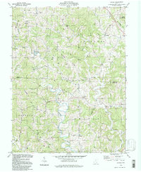
1994 Map of Alfred
USGS Topo · Published 1998About this map
The Middle Branch Shade River and its numerous tributaries carve a complex landscape of ridges and hollows across the border of Athens and Meigs counties. This late 20th-century survey reveals a region deeply defined by its subsurface resources, with hundreds of Oil Wells and Gas Wells dotting the hillsides from Lodi to Orange. Small crossroads communities and family-named landmarks suggest a long history of local settlement, anchored by rural congregations such as St Johns Ch and Zion Ch.
Find a feature on this map
56 named features on this map. Tap any name to fly to it.
Don’t see what you’re looking for? This feature index may not catch every label — zoom into the map to look around manually.
Map Details
Editions of this 1994 Alfred Map
This is the sole edition of this map. No revisions or reprints were ever made.
Other maps of this area

1903 · Athens
USGS Topo · 1:62,500

1904 · Chesterhill
USGS Topo · 1:62,500

1905 · Athens
USGS Topo · 1:62,500

1906 · Chesterhill
USGS Topo · 1:62,500

1907 · Pomeroy
USGS Topo · 1:62,500

1907 · Keno
USGS Topo · 1:62,500

1947 · Columbus
USGS Topo · 1:250,000

1949 · Clarksburg
USGS Topo · 1:250,000

1956 · Clarksburg
USGS Topo · 1:250,000
1960 · Alfred
USGS Topo · 1:24,000