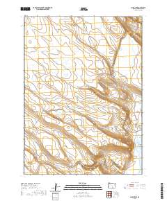
2020 Map of Alger Lake
USGS Topo · Published 2020About this map
Alger Lake and its surrounding high-desert basin dominate this Lake County landscape, where water dictates the location of every named feature. This area is defined by a series of ephemeral lakes and ponds, including Dobyns Lake, Desert Lake, and the small Nora Pond, which collection surface runoff in a semi-arid environment. The presence of Hitching Post Water Hole and the Coffee Pot Reservoir indicates the critical importance of water management for cattle ranching and land use in this part of Oregon.
Find a feature on this map
21 named features on this map. Tap any name to fly to it.
Don’t see what you’re looking for? This feature index may not catch every label — zoom into the map to look around manually.
Map Details
Editions of this 2020 Alger Lake Map
This is the sole edition of this map. No revisions or reprints were ever made.
Other maps of this area

1955 · Adel
USGS Topo · 1:250,000

1957 · Adel
USGS Topo · 1:250,000

1958 · Adel
USGS Topo · 1:250,000

1962 · Adel
USGS Topo · 1:250,000

1967 · Jacobs Reservoir
USGS Topo · 1:24,000

1967 · Alger Lake
USGS Topo · 1:24,000

1967 · Warner Peak
USGS Topo · 1:24,000

1967 · Swede Knoll
USGS Topo · 1:24,000

1968 · Guano Lake
USGS Topo · 1:24,000
1968 · Mud Lake Reservoir
USGS Topo · 1:24,000