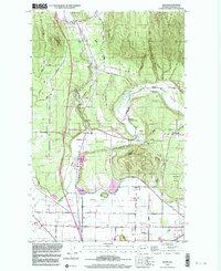
1998 Map of Alger
USGS Topo · Published 2003About this map
Alger serves as a northern hub for this part of Skagit County, situated where Friday Creek and Silver Lake meet the foothills of Anderson Mtn. The landscape is a mix of agricultural lowlands and timbered ridges, defined by the broad stretches of Jarman Prairie and Butler Flat. This era shows a community rooted in both land and industry, evidenced by the State Salmon Hatchery and local gathering spots like the Silver Run Grange and Hickson Community Hall. Cultural and recreational sites are well-established, including the Upper Skagit Indian Reservation and the Skagit Speedway. For those tracing local families, the map details many small roads and sites like the Garden of Eden and the Allen Sch at the southern edge, while resource extraction is noted through several sandpits and a brickyard.
Find a feature on this map
45 named features on this map. Tap any name to fly to it.
Don’t see what you’re looking for? This feature index may not catch every label — zoom into the map to look around manually.
Map Details
Editions of this 1998 Alger Map
This is the sole edition of this map. No revisions or reprints were ever made.
Other maps of this area

1911 · Mount Vernon
USGS Topo · 1:125,000

1918 · Samish Lake
USGS Topo · 1:62,500

1921 · Wickersham
USGS Topo · 1:62,500

1940 · Mt Vernon
USGS Topo · 1:62,500

1943 · Mt Vernon
USGS Topo · 1:62,500

1944 · Clear Lake
USGS Topo · 1:62,500

1951 · Wickersham
USGS Topo · 1:62,500

1952 · Lake Whatcom
USGS Topo · 1:24,000

1952 · Alger
USGS Topo · 1:24,000

1954 · Bow
USGS Topo · 1:24,000