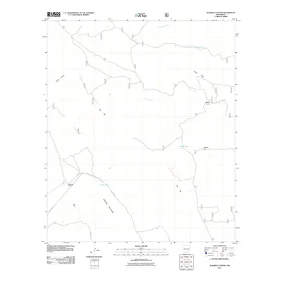
2011 Map of Algerita Canyon
USGS Topo · Published 2011About this map
The Brokeoff Mountains dominate this high-desert landscape in Otero County, defined by the sharp topographic break of The Rim. This 2011 survey by the U.S. Geological Survey and U.S. Forest Service captures a network of water catchment systems essential for ranching and wildlife in an arid environment, including Calvin Tank, Algerita Tank, and Jeffrey Tank. The area is characterized by dramatic elevation changes where the level ground of Algerita Flat meets the steep descents of Algerita Canyon and Big Dog Canyon. Infrastructure is minimal, consisting of remote access routes like County Rd-G014 and County Rd-G23, which navigate the rugged terrain around Woods Canyon and Powers Ridge. This map illustrates the intersection of public land management and the natural drainage patterns of North Rocky Arroyo and Indian Creek.
Find a feature on this map
18 named features on this map. Tap any name to fly to it.
Don’t see what you’re looking for? This feature index may not catch every label — zoom into the map to look around manually.
Map Details
Editions of this 2011 Algerita Canyon Map
This is the sole edition of this map. No revisions or reprints were ever made.
Other maps of this area

1935 · El Paso Gap
USGS Topo · 1:62,500

1936 · El Paso Gap
USGS Topo · 1:48,000

1940 · El Paso Gap
USGS Topo · 1:62,500

1943 · Texas Hill
USGS Topo · 1:62,500

1945 · Texas Hill
USGS Topo · 1:62,500

1954 · Carlsbad
USGS Topo · 1:250,000

1958 · Carlsbad
USGS Topo · 1:250,000

1963 · Gowdy Ranch
USGS Topo · 1:24,000

1963 · Panama Ranch
USGS Topo · 1:24,000
1969 · Sheep Draw
USGS Topo · 1:24,000