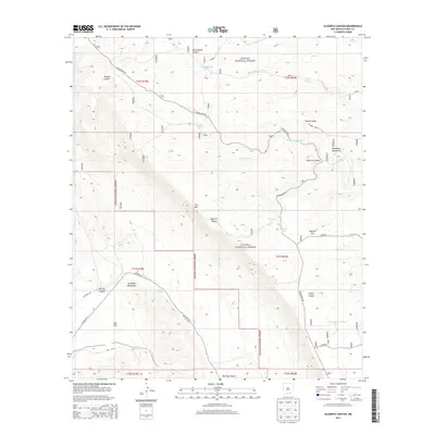
2013 Map of Algerita Canyon
USGS Topo · Published 2013About this map
The Guadalupe Rim snakes across this high-desert landscape in Otero County, marking a dramatic transition between the high plateaus and deep canyon systems. Within the Lincoln National Forest, the terrain is defined by extreme relief, featuring the Brokeoff Mountains and the prominent cliff face of The Rim. The area's ranching and livestock heritage is evident through a sophisticated network of water management features, including the Coon Dog Storage Tank, Powers Storage Tank, and the Ultimo Water Storage Tank, all essential for survival in this arid environment. These water sources are scattered among landmarks like Algerita Flat and Powers Ridge. Access to these remote reaches of the Guadalupe Mountains is provided by rugged paths such as Co Road G014 and Rawhide, which navigate the steep descent into Big Dog Canyon and toward the expansive Salt Flat to the southwest.
Find a feature on this map
35 named features on this map. Tap any name to fly to it.
Don’t see what you’re looking for? This feature index may not catch every label — zoom into the map to look around manually.
Map Details
Editions of this 2013 Algerita Canyon Map
This is the sole edition of this map. No revisions or reprints were ever made.
Other maps of this area

1935 · El Paso Gap
USGS Topo · 1:62,500

1936 · El Paso Gap
USGS Topo · 1:48,000

1940 · El Paso Gap
USGS Topo · 1:62,500

1943 · Texas Hill
USGS Topo · 1:62,500

1945 · Texas Hill
USGS Topo · 1:62,500

1954 · Carlsbad
USGS Topo · 1:250,000

1958 · Carlsbad
USGS Topo · 1:250,000

1963 · Gowdy Ranch
USGS Topo · 1:24,000

1963 · Panama Ranch
USGS Topo · 1:24,000
1969 · Sheep Draw
USGS Topo · 1:24,000