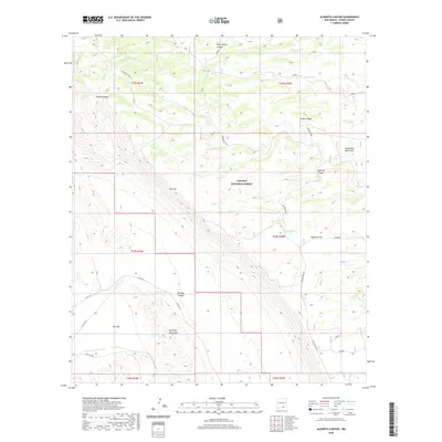
2020 Map of Algerita Canyon
USGS Topo · Published 2020About this map
The Guadalupe Rim defines this high-desert landscape within the Lincoln National Forest, where steep vertical drops separate elevated plateaus from low-lying basins. The geography is characterized by dramatic escarpments like The Rim and the Brokeoff Mountains, which overlook a vast Salt Flat to the southwest. Human presence in this arid Otero County environment is marked primarily by ranching infrastructure and remote access roads such as Rawhide and Box Canyon. Essential water sources for livestock and local fauna are captured at scattered catchments, including Calvin Tank, Jeffrey Tank, and Algerita Tank. The map reveals the intricate drainage patterns of Algerita Canyon and Big Dog Canyon as they carve through the limestone layers of the Guadalupe Mountains, providing a detailed look at the transition between mountain ridges and open plains at Algerita Flat.
Find a feature on this map
31 named features on this map. Tap any name to fly to it.
Don’t see what you’re looking for? This feature index may not catch every label — zoom into the map to look around manually.
Map Details
Editions of this 2020 Algerita Canyon Map
This is the sole edition of this map. No revisions or reprints were ever made.
Other maps of this area

1935 · El Paso Gap
USGS Topo · 1:62,500

1936 · El Paso Gap
USGS Topo · 1:48,000

1940 · El Paso Gap
USGS Topo · 1:62,500

1943 · Texas Hill
USGS Topo · 1:62,500

1945 · Texas Hill
USGS Topo · 1:62,500

1954 · Carlsbad
USGS Topo · 1:250,000

1958 · Carlsbad
USGS Topo · 1:250,000

1963 · Gowdy Ranch
USGS Topo · 1:24,000

1963 · Panama Ranch
USGS Topo · 1:24,000
1969 · Sheep Draw
USGS Topo · 1:24,000