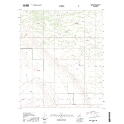
2023 Map of Algerita Canyon
USGS Topo · Published 2023About this map
Lincoln National Forest land and the sharp drop-offs of the Guadalupe Rim define this area of Otero County in the early 2020s. This survey focuses on the dramatic topography of the Guadalupe Mountains and the southern Brokeoff Mountains, where elevations vary from the high ground of Powers Ridge to the low expanse of Salt Flat. The map documents a network of essential water resources in this arid environment, including Calvin Tank, Jeffrey Tank, and Algerita Tank, which provided vital collection points for livestock and wildlife. Canyons such as Big Dog Canyon and Box Canyon cut through the limestone terrain, while the sharp escarpment of The Rim provides a clear boundary between the high plateaus and the valley floor below.
Find a feature on this map
25 named features on this map. Tap any name to fly to it.
Don’t see what you’re looking for? This feature index may not catch every label — zoom into the map to look around manually.
Map Details
Editions of this 2023 Algerita Canyon Map
This is the sole edition of this map. No revisions or reprints were ever made.
Other maps of this area

1935 · El Paso Gap
USGS Topo · 1:62,500

1936 · El Paso Gap
USGS Topo · 1:48,000

1940 · El Paso Gap
USGS Topo · 1:62,500

1943 · Texas Hill
USGS Topo · 1:62,500

1945 · Texas Hill
USGS Topo · 1:62,500

1954 · Carlsbad
USGS Topo · 1:250,000

1958 · Carlsbad
USGS Topo · 1:250,000

1963 · Gowdy Ranch
USGS Topo · 1:24,000

1963 · Panama Ranch
USGS Topo · 1:24,000
1969 · Sheep Draw
USGS Topo · 1:24,000