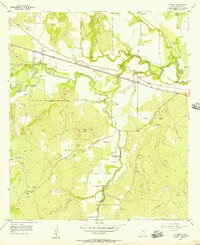
1956 Map of Algerita
USGS Topo · Published 1957About this map
San Saba River meanders through the Texas Hill Country in this mid-century survey, creating a fertile valley flanked by the prominent Harkey Knobs. The Gulf Colorado and Santa Fe (AT & SF) railroad cuts a straight line across the northern landscape, connecting the small settlement of Algerita with the community of Harkeyville. This era reveals a rural landscape deeply tied to its local geography, where community life centered around the Wallace Creek Sch and the several family and community burial grounds, including China Creek Cemetery and Wallace Creek Cemetery. The topography is marked by numerous small tributaries like Billie Branch and Robbins Branch, alongside various resource extraction sites such as an inactive Gravel Pit and several abandoned caliche pits, indicating the local materials used for regional road building and construction.
Find a feature on this map
24 named features on this map. Tap any name to fly to it.
Don’t see what you’re looking for? This feature index may not catch every label — zoom into the map to look around manually.
Map Details
Editions of this 1956 Algerita Map
2 editions found
Other maps of this area

1885 · San Saba
USGS Topo · 1:125,000

1894 · San Saba
USGS Topo · 1:125,000

1925 · San Saba 1-c
USGS Topo · 1:48,000

1928 · Goldthwaite
USGS Topo · 1:62,500

1930 · Richland Springs
USGS Topo · 1:62,500

1931 · Bend
USGS Topo · 1:62,500

1948 · Richland Springs
USGS Topo · 1:62,500

1948 · Goldthwaite
USGS Topo · 1:62,500
1950 · Richland Springs
USGS Topo · 1:62,500
1950 · Goldthwaite
USGS Topo · 1:62,500