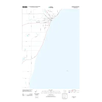
2013 Map of Algoma
USGS Topo · Published 2013About this map
The Ahnapee River winds its way through the landscape before emptying into Lake Michigan at the harbor of Algoma, a focal point of this coastal Wisconsin survey. This portion of Kewaunee County showcases a transition from the structured street grid of the lakefront community to the more dispersed settlement of Bruemmerville to the west. The local infrastructure is anchored by the Algoma Utilities Commission, while the surrounding geography is defined by a series of small, distinctive water bodies including Krohns Lake, Silver Lake, and E Alaska Lake. Numerous watercourses such as Silver Creek, Threemile Cr, and Mashek Cr drain the interior uplands toward the Great Lake shore, illustrating the hydrologic patterns that have shaped land use and local development in the region.
Find a feature on this map
54 named features on this map. Tap any name to fly to it.
Don’t see what you’re looking for? This feature index may not catch every label — zoom into the map to look around manually.
Map Details
Editions of this 2013 Algoma Map
This is the sole edition of this map. No revisions or reprints were ever made.
Other maps of this area

1952 · Casco
USGS Topo · 1:62,500

1954 · Kewaunee
USGS Topo · 1:62,500

1954 · Manitowoc
USGS Topo · 1:250,000

1958 · Manitowoc
USGS Topo · 1:250,000

1960 · Algoma
USGS Topo · 1:62,500

1978 · Casco
USGS Topo · 1:24,000

1978 · Brussels
USGS Topo · 1:24,000
1978 · Kewaunee
USGS Topo · 1:24,000
1982 · Algoma
USGS Topo · 1:24,000
1982 · Algoma NE
USGS Topo · 1:24,000