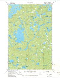
1960 Map of Alice Lake
USGS Topo · Published 1982About this map
The Kawishiwi River winds through a dense network of interconnected waterways in this 1960 survey of Lake County, highlighting the complex hydrology of northeastern Minnesota. Large bodies of water like Alice Lake, Thomas Lake, and Adams Lake dominate the landscape, separated by narrow portages and rocky outcrops typical of the Superior National Forest. The map documents a wilderness character preserved before modern expansion, with the Minnesota State Forest boundary clearly defined. Human presence is remarkably sparse, indicated primarily by a Restricted Jeep Trail and few other land-based routes. Many smaller lakes carry evocative names such as Fishdance Lake, Struggle Lake, and Blissful Lake, suggesting the early recreational and surveying history of the region. This topography reflects the deep glacial scouring that formed the Boundary Waters area, showing the intricate relationship between the river systems and the countless lakes like Beaver Lake and Malberg Lake.
Find a feature on this map
52 named features on this map. Tap any name to fly to it.
Don’t see what you’re looking for? This feature index may not catch every label — zoom into the map to look around manually.
Map Details
Editions of this 1960 Alice Lake Map
4 editions found

Other maps of this area

1954 · Two Harbors
USGS Topo · 1:250,000

1957 · Two Harbors
USGS Topo · 1:250,000

1957 · Ensign Lake
USGS Topo · 1:62,500

1957 · Quetico
USGS Topo · 1:250,000

1958 · Two Harbors
USGS Topo · 1:250,000

1959 · Ogishkemuncie Lake
USGS Topo · 1:24,000

1959 · Kekekabic Lake
USGS Topo · 1:24,000

1960 · Lake Polly
USGS Topo · 1:24,000

1960 · Kawishiwi Lake
USGS Topo · 1:24,000

1960 · Perent Lake
USGS Topo · 1:24,000