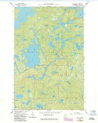
1960 Map of Alice Lake
USGS Topo · Published 1986About this map
Alice Lake forms the central hub of this northern water system, situated within the vast protected reaches of the Superior National Forest. This mapping, updated in the mid-1980s from earlier 1960 surveys, documents the intricate landscape of the Boundary Waters Canoe Area Wilderness. The geography is defined by a dense network of interconnected basins including Thomas Lake, Fraser Lake, and Adams Lake, all linked by the winding course of the Kawishiwi River. Many of the smaller water bodies carry distinctive names like Blissful Lake, Struggle Lake, and Caveman Lake, reflecting the character of the portage routes and campsites used by travelers. The lack of roads or permanent structures emphasizes the wilderness designation, highlighting a landscape preserved for its natural hydrology and original drainage patterns through the Malberg Lake and Amber Lake regions.
Find a feature on this map
49 named features on this map. Tap any name to fly to it.
Don’t see what you’re looking for? This feature index may not catch every label — zoom into the map to look around manually.
Map Details
Editions of this 1960 Alice Lake Map
4 editions found

Other maps of this area

1954 · Two Harbors
USGS Topo · 1:250,000

1957 · Two Harbors
USGS Topo · 1:250,000

1957 · Ensign Lake
USGS Topo · 1:62,500

1957 · Quetico
USGS Topo · 1:250,000

1958 · Two Harbors
USGS Topo · 1:250,000

1959 · Ogishkemuncie Lake
USGS Topo · 1:24,000

1959 · Kekekabic Lake
USGS Topo · 1:24,000

1960 · Lake Polly
USGS Topo · 1:24,000

1960 · Kawishiwi Lake
USGS Topo · 1:24,000

1960 · Perent Lake
USGS Topo · 1:24,000