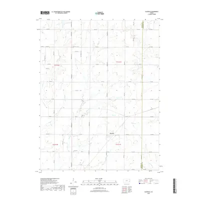
2018 Map of Aliceville
USGS Topo · Published 2018About this map
Aliceville anchors this survey of eastern Kansas prairie, sitting just west of the Coffey Co Anderson Co boundary. The landscape is defined by the dendritic drainage patterns of several tributaries, including Silver Cr and Crooked Cr, which cut through the agricultural sections. This map is particularly valuable for genealogical research, as it identifies several small rural burial grounds scattered across the townships, such as Star Cem in the north and Quisling Cem further south. The straight-line grid of rural roads, such as 9th Rd SE and SW 1000 Rd, illustrates the persistent influence of the Public Land Survey System on the modern Kansas countryside. Other notable landmarks include Saint Johns Cem and the waters of Little Indian Cr in the southeastern corner.
Find a feature on this map
56 named features on this map. Tap any name to fly to it.
Don’t see what you’re looking for? This feature index may not catch every label — zoom into the map to look around manually.
Map Details
Editions of this 2018 Aliceville Map
This is the sole edition of this map. No revisions or reprints were ever made.
Other maps of this area

1885 · Burlington
USGS Topo · 1:125,000

1885 · Garnett
USGS Topo · 1:125,000

1894 · Garnett
USGS Topo · 1:125,000

1894 · Burlington
USGS Topo · 1:125,000

1947 · Lawrence
USGS Topo · 1:250,000

1950 · Lawrence
USGS Topo · 1:250,000

1956 · Lawrence
USGS Topo · 1:250,000

1961 · Lawrence
USGS Topo · 1:250,000
1966 · Westphalia
USGS Topo · 1:24,000
1966 · Harris
USGS Topo · 1:24,000