
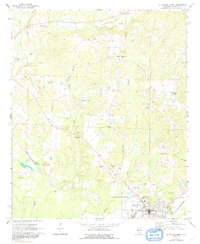
1970 Map of Aliceville North
USGS Topo · Published 1972About this map
Aliceville anchors the southern portion of this Alabama landscape, serving as a hub for the surrounding rural communities of Garden and Sapps in the early 1970s. The town's infrastructure is clearly defined, featuring the Armory, Hospital, and Kirksey High Sch. The St Louis-San Francisco railroad cuts a diagonal path through the terrain, connecting the municipal center to the outlying agricultural areas and resource extraction sites like the local Claypit and various Gravel Pit locations.
Find a feature on this map
41 named features on this map. Tap any name to fly to it.
Don’t see what you’re looking for? This feature index may not catch every label — zoom into the map to look around manually.
Map Details
Editions of this 1970 Aliceville North Map
2 editions found
Other maps of this area

1953 · West Point
USGS Topo · 1:250,000

1958 · West Point
USGS Topo · 1:250,000

1960 · Columbus
USGS Topo · 1:62,500

1963 · West Point
USGS Topo · 1:250,000

1966 · Reform SW
USGS Topo · 1:24,000

1967 · Carrollton
USGS Topo · 1:24,000
1970 · Cunningham
USGS Topo · 1:24,000
1970 · Pleasant Ridge
USGS Topo · 1:24,000

1970 · Aliceville South
USGS Topo · 1:24,000
1974 · Dancy
USGS Topo · 1:24,000