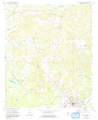
1970 Map of Aliceville North
USGS Topo · Published 1991About this map
Aliceville sits at the southern edge of this West Alabama landscape, where the St Louis-San Francisco railroad cuts through the terrain near the Armory and local Hospital. The geography is defined by a dense network of watercourses including Big Creek, Blubber Creek, and Beaver Creek, which influenced the placement of numerous rural congregations and burial grounds. Small settlements and named communities such as Sapps, Beaver Town, and Garden are scattered across the quadrangle, connected by winding country roads that link local landmarks like Kirksey High Sch. Family history is deeply rooted here, evidenced by the high density of named cemeteries including Franconia Cem, Pilgrim Rest Cem, and Fleming Cem. The presence of a Claypit and several Gravel Pits suggests the localized extraction industries that operated alongside the region's agricultural base during the mid-20th century.
Find a feature on this map
45 named features on this map. Tap any name to fly to it.
Don’t see what you’re looking for? This feature index may not catch every label — zoom into the map to look around manually.
Map Details
Editions of this 1970 Aliceville North Map
2 editions found
Other maps of this area

1953 · West Point
USGS Topo · 1:250,000

1958 · West Point
USGS Topo · 1:250,000

1960 · Columbus
USGS Topo · 1:62,500

1963 · West Point
USGS Topo · 1:250,000

1966 · Reform SW
USGS Topo · 1:24,000

1967 · Carrollton
USGS Topo · 1:24,000

1970 · Aliceville North
USGS Topo · 1:24,000
1970 · Cunningham
USGS Topo · 1:24,000
1970 · Pleasant Ridge
USGS Topo · 1:24,000

1970 · Aliceville South
USGS Topo · 1:24,000