
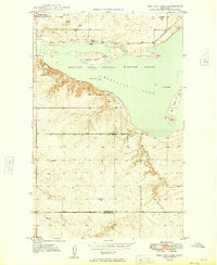
1949 Map of Alkali Coulee
USGS Topo · Published 1949About this map
Fort Peck Indian Reservation land dominates this 1940s landscape in Sheridan County, where the high prairie meets the water systems of the Missouri River Basin. The map details a period of hydraulic management and resource extraction, characterized by the Diversion Ditch No 1 and a local Coal Mine tucked into the coulees. The southeastern corner reveals the community of Medicine Lake, a vital rail stop along the Great Northern railroad line.
Find a feature on this map
14 named features on this map. Tap any name to fly to it.
Don’t see what you’re looking for? This feature index may not catch every label — zoom into the map to look around manually.
Map Details
Editions of this 1949 Alkali Coulee Map
This is the sole edition of this map. No revisions or reprints were ever made.
Other maps of this area

1914 · Homestead
USGS Topo · 1:62,500

1947 · Homestead
USGS Topo · 1:24,000

1948 · Homestead
USGS Topo · 1:24,000

1948 · Medicine Lake
USGS Topo · 1:24,000

1948 · Reserve
USGS Topo · 1:24,000

1948 · Alkali Coulee
USGS Topo · 1:24,000

1948 · Antelope
USGS Topo · 1:24,000

1949 · Reserve
USGS Topo · 1:24,000

1949 · Antelope
USGS Topo · 1:24,000
1949 · Medicine Lake
USGS Topo · 1:24,000