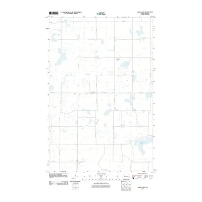
2011 Map of Alkali Lake
USGS Topo · Published 2011About this map
Alkali Lake dominates the southeastern corner of this McLean County landscape, while the southern margin captures the northern reach of Cherry Lake. This portion of North Dakota is defined by a dense network of glacial potholes and small prairie wetlands, illustrating the unique hydrology of the drift prairie region. The section-line road grid remains the primary organizing feature of the terrain, with routes like County Hwy-33 and McLean Co 35 providing access across the township lines. A notable human landmark is Harchenko Field, situated in the northern half of the quadrangle. This map reflects a contemporary snapshot of a rural agricultural landscape where modern infrastructure and a naming system of numbered avenues and streets overlay a complex natural system of water bodies and intermittent basins.
Find a feature on this map
23 named features on this map. Tap any name to fly to it.
Don’t see what you’re looking for? This feature index may not catch every label — zoom into the map to look around manually.
Map Details
Editions of this 2011 Alkali Lake Map
This is the sole edition of this map. No revisions or reprints were ever made.
Other maps of this area

1929 · Kongsberg
USGS Topo · 1:62,500

1929 · Balfour
USGS Topo · 1:62,500

1945 · Pelican Lake
USGS Topo · 1:62,500

1947 · Pelican Lake
USGS Topo · 1:62,500

1947 · Turtle Lake
USGS Topo · 1:62,500

1954 · McClusky
USGS Topo · 1:250,000

1958 · McClusky
USGS Topo · 1:250,000

1958 · Butte
USGS Topo · 1:24,000

1958 · Balfour
USGS Topo · 1:62,500
1958 · Kief
USGS Topo · 1:24,000