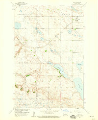
1958 Map of Kief
USGS Topo · Published 1959About this map
Kief serves as the focal point of this prairie landscape, where the Minneapolis Sault Ste Marie and St Paul railroad cuts diagonally across the northern townships. The terrain is defined by a dense concentration of glacial potholes and larger bodies of water, including Cottonwood Lake and the elongated Moesner Lake. To the south and west, the elevation rises into the prominent Dogden hills, creating a stark contrast to the flatter lake country of the north.
Find a feature on this map
14 named features on this map. Tap any name to fly to it.
Don’t see what you’re looking for? This feature index may not catch every label — zoom into the map to look around manually.
Map Details
Editions of this 1958 Kief Map
This is the sole edition of this map. No revisions or reprints were ever made.
Other maps of this area

1929 · Balfour
USGS Topo · 1:62,500

1930 · Drake
USGS Topo · 1:62,500

1945 · Pelican Lake
USGS Topo · 1:62,500

1947 · Pelican Lake
USGS Topo · 1:62,500

1947 · Lincoln Valley
USGS Topo · 1:62,500

1954 · McClusky
USGS Topo · 1:250,000

1958 · McClusky
USGS Topo · 1:250,000

1958 · Butte
USGS Topo · 1:24,000
1958 · Balfour NW
USGS Topo · 1:24,000

1958 · Drake
USGS Topo · 1:62,500