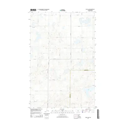
2014 Map of Alkali Lake
USGS Topo · Published 2014About this map
Alkali Lake dominates the southeastern quadrant of this prairie landscape, where the flat terrain of the Great Plains is defined by an orderly grid of section lines and gravel roads. In the early 21st century, the boundary between McLean Co and Sheridan Co divides this rural area, which is characterized by numerous small, seasonal prairie potholes and depressions typical of North Dakota's glaciated plains. To the south, Cherry Lake sits just across the county line, providing a natural focal point in a region otherwise dominated by large-scale agricultural blocks. The map reveals the precise layout of rural routes like 19th St NW and 4th Ave NW, which serve the scattered farmsteads and manage the drainage patterns of this quiet, water-dotted interior.
Find a feature on this map
19 named features on this map. Tap any name to fly to it.
Don’t see what you’re looking for? This feature index may not catch every label — zoom into the map to look around manually.
Map Details
Editions of this 2014 Alkali Lake Map
This is the sole edition of this map. No revisions or reprints were ever made.
Other maps of this area

1929 · Kongsberg
USGS Topo · 1:62,500

1929 · Balfour
USGS Topo · 1:62,500

1945 · Pelican Lake
USGS Topo · 1:62,500

1947 · Pelican Lake
USGS Topo · 1:62,500

1947 · Turtle Lake
USGS Topo · 1:62,500

1954 · McClusky
USGS Topo · 1:250,000

1958 · McClusky
USGS Topo · 1:250,000

1958 · Butte
USGS Topo · 1:24,000

1958 · Balfour
USGS Topo · 1:62,500
1958 · Kief
USGS Topo · 1:24,000