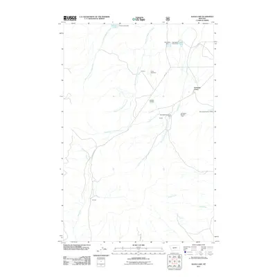
2011 Map of Alkali Lake
USGS Topo · Published 2011About this map
Springdale Colony serves as a primary point of interest in this high-plains landscape, where a sophisticated network of small-scale water management infrastructure defines the local geography. Numerous named impoundments, including the uniquely titled Screwed Up Dam, Onion Head Dam, and several numerical reservoirs like Springdale Number 2 Dam, illustrate the critical importance of water conservation for agriculture and livestock in Meagher County. The terrain is deeply etched by various drainage systems, notably the forks of Cooks Creek and Woods Gulch Creek, which feed into the larger basins of Alkali Lake and Jackson Lake. Local movement is facilitated by rural routes such as Birky Rd and Elk Ridge Rd, while the settlement of Shindahl sits at the southwestern edge of the quadrangle near the banks of Deep Creek.
Find a feature on this map
25 named features on this map. Tap any name to fly to it.
Don’t see what you’re looking for? This feature index may not catch every label — zoom into the map to look around manually.
Map Details
Editions of this 2011 Alkali Lake Map
This is the sole edition of this map. No revisions or reprints were ever made.
Other maps of this area

1886 · Fort Logan
USGS Topo · 1:250,000

1886 · Little Belt Mts.
USGS Topo · 1:250,000

1894 · Little Belt Mts.
USGS Topo · 1:250,000

1897 · Little Belt Mts.
USGS Topo · 1:250,000

1898 · Little Belt Mts.
USGS Topo · 1:250,000

1902 · Little Belt Mts.
USGS Topo · 1:250,000

1948 · White Sulphur Springs
USGS Topo · 1:250,000
1951 · Black Butte Mountain
USGS Topo · 1:24,000

1958 · White Sulphur Springs
USGS Topo · 1:250,000

1961 · White Sulphur Springs
USGS Topo · 1:250,000