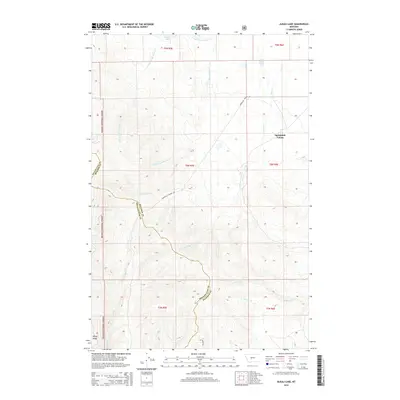
2014 Map of Alkali Lake
USGS Topo · Published 2014About this map
Springdale Colony sits at the heart of this landscape where the high plains meet the eastern fringes of the Helena National Forest. The geography is defined by a complex network of seasonal drainages, including the N Fork Woods Gulch Cr and S Fork Woods Gulch Cr which cut through the northern sections near Jackson Lake. These watercourses reveal the traditional drainage patterns of Meagher County, flowing toward basins like Alkali Lake.
Find a feature on this map
23 named features on this map. Tap any name to fly to it.
Don’t see what you’re looking for? This feature index may not catch every label — zoom into the map to look around manually.
Map Details
Editions of this 2014 Alkali Lake Map
This is the sole edition of this map. No revisions or reprints were ever made.
Other maps of this area

1886 · Fort Logan
USGS Topo · 1:250,000

1886 · Little Belt Mts.
USGS Topo · 1:250,000

1894 · Little Belt Mts.
USGS Topo · 1:250,000

1897 · Little Belt Mts.
USGS Topo · 1:250,000

1898 · Little Belt Mts.
USGS Topo · 1:250,000

1902 · Little Belt Mts.
USGS Topo · 1:250,000

1948 · White Sulphur Springs
USGS Topo · 1:250,000
1951 · Black Butte Mountain
USGS Topo · 1:24,000

1958 · White Sulphur Springs
USGS Topo · 1:250,000

1961 · White Sulphur Springs
USGS Topo · 1:250,000