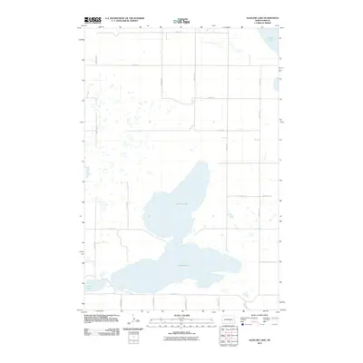
2011 Map of Alkaline Lake
USGS Topo · Published 2011About this map
Alkaline Lake dominates this prairie landscape in Kidder County, appearing as a significant divided water body surrounded by a geometric grid of rural section roads. The 2011 survey reveals the hydrological character of the Missouri Coteau region, where terminal moraines created numerous depressions now filled with water. To the northwest, Fresh Lake sits adjacent to the larger alkaline basin, while Lake George occupies the northeast corner of the quadrangle. The transport network is defined by a rigorous grid of section-line roads, including 54th St SE and 46th Ave SE, which facilitate access to the surrounding agricultural land. This map reflects the enduring township-and-range surveying system that has dictated the North Dakota settlement pattern for over a century, showing the relationship between these glacial lakes and the maintained rural infrastructure.
Find a feature on this map
18 named features on this map. Tap any name to fly to it.
Don’t see what you’re looking for? This feature index may not catch every label — zoom into the map to look around manually.
Map Details
Editions of this 2011 Alkaline Lake Map
This is the sole edition of this map. No revisions or reprints were ever made.
Other maps of this area

1952 · Tappen South
USGS Topo · 1:24,000

1952 · Tappen SE
USGS Topo · 1:24,000

1953 · Jamestown
USGS Topo · 1:250,000

1955 · Medina SW
USGS Topo · 1:24,000

1956 · Jamestown
USGS Topo · 1:250,000

1975 · Medina SW
USGS Topo · 1:24,000

1983 · Streeter SW
USGS Topo · 1:24,000

1983 · Alkaline Lake SW
USGS Topo · 1:24,000

1983 · Alkaline Lake
USGS Topo · 1:24,000

1983 · Streeter NW
USGS Topo · 1:24,000