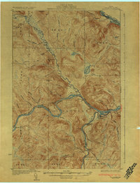
1933 Map of Allagash
USGS Topo · Published 1933About this map
The confluence of the St John River and the Little Black River anchors this 1930s survey of the northern Maine borderlands. In an era when river transport and overland trails were vital to the regional economy, the map documents the settlement at Dickey and various riverside outposts like Gardner and Boat Landing Camp. Education in these isolated townships was managed through several local schools, including Log Cabin Sch, Kelly Sch, and Lindberg Sch. The terrain is defined by a dense network of waterways such as Carrie Bogan Brook and Aegan Bk, leading toward the international boundary at the St Francis River. Evidence of the logging and transit history is found in the Tote Road and the Rocky Mountain Trail, which provided essential inland access before modern highway development changed the Aroostook County landscape.
Find a feature on this map
64 named features on this map. Tap any name to fly to it.
Don’t see what you’re looking for? This feature index may not catch every label — zoom into the map to look around manually.
Map Details
Editions of this 1933 Allagash Map
3 editions found
Other maps of this area

1930 · Allagash
USGS Topo · 1:48,000

1930 · St Francis
USGS Topo · 1:48,000

1931 · Fish River Lake
USGS Topo · 1:48,000

1932 · Allagash Falls
USGS Topo · 1:48,000

1933 · Allagash
USGS Topo · 1:62,500

1933 · St Francis
USGS Topo · 1:62,500

1935 · Fish River Lake
USGS Topo · 1:62,500

1935 · Allagash Falls
USGS Topo · 1:62,500

1954 · Presque Isle
USGS Topo · 1:250,000

1955 · Rocky Mountain
USGS Topo · 1:62,500