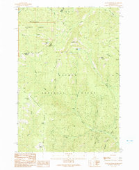
1991 Map of Allan Mountain
USGS Topo · Published 1991About this map
Allan Mountain stands as a prominent landmark along the border between Ravalli Co and Lemhi Co, marking a high point in the high country where the Bitterroot National Forest meets the Salmon National Forest. This 1991 provisional survey documents a landscape defined by sharp elevation changes and a complex drainage system, including Hughes Creek and the North Fork Salzer Creek. For researchers, the map reveals specific signs of historic resource extraction, notably a Mine Shaft and several Prospect sites located near the upper reaches of Allan Creek. High-altitude water sources like Burrell Lake, Allan Lake, and Bear Wallow Spring are interspersed throughout the timbered slopes. The presence of primitive routes like the (Pack) Trail and Ax Park Way underscores the area's isolation and its historical use for pack animal transit across the Montana-Idaho state line.
Find a feature on this map
35 named features on this map. Tap any name to fly to it.
Don’t see what you’re looking for? This feature index may not catch every label — zoom into the map to look around manually.
Map Details
Editions of this 1991 Allan Mountain Map
2 editions found
Other maps of this area

1955 · Dillon
USGS Topo · 1:250,000

1956 · Elk City
USGS Topo · 1:250,000

1957 · Dillon
USGS Topo · 1:250,000

1958 · Dillon
USGS Topo · 1:250,000

1960 · Elk City
USGS Topo · 1:250,000

1960 · Ulysses Mtn
USGS Topo · 1:62,500

1960 · Piquett Mountain
USGS Topo · 1:62,500

1962 · Dillon
USGS Topo · 1:250,000

1965 · Dillon
USGS Topo · 1:250,000

1966 · Lost Trail Pass
USGS Topo · 1:24,000