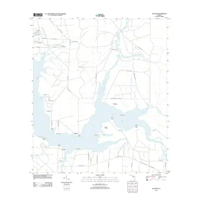
2012 Map of Allanton
USGS Topo · Published 2012About this map
East Bay dominates this coastal landscape, where the confluence of several bayous and creeks defines the local geography. The settlement of Allanton sits on the western shore, anchored by Allan Point and Murray Point, while the community of Farmdale lies just south of Baker Bayou. This 2012 survey illustrates a mix of traditional maritime environments and specialized aviation facilities, most notably the Sandy Creek Airpark located inland from Smith Bayou. Extensive wetlands like Bear Swamp and California Swamp border the tidal waters, creating a complex network of marshes and inlets such as Lathrop Bayou and Horseshoe Bayou. Researchers can trace the layout of coastal developments and older landmarks, including the Farmdale Cem and various points along the shoreline like Bull Point and Coffee Pot Point, which have historically served as navigational markers for the region's water-based transport and fishing.
Find a feature on this map
68 named features on this map. Tap any name to fly to it.
Don’t see what you’re looking for? This feature index may not catch every label — zoom into the map to look around manually.
Map Details
Editions of this 2012 Allanton Map
This is the sole edition of this map. No revisions or reprints were ever made.
Other maps of this area

1943 · Overstreet
USGS Topo · 1:31,680

1943 · Crooked Island
USGS Topo · 1:31,680

1944 · Beacon Hill
USGS Topo · 1:31,680

1944 · Long Point
USGS Topo · 1:31,680

1945 · Allanton
USGS Topo · 1:31,680

1945 · North Of Allanton
USGS Topo · 1:31,680

1945 · Wetappo Creek
USGS Topo · 1:31,680

1945 · Tenmile Swamp
USGS Topo · 1:31,680
1945 · Parker
USGS Topo · 1:31,680

1947 · Allanton
USGS Topo · 1:25,000