
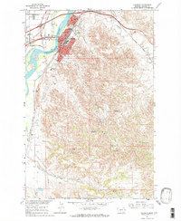
1967 Map of Allard
USGS Topo · Published 1970About this map
The Northern Pacific railroad cuts a diagonal path across this Dawson County landscape, anchoring the small settlements of Allard and Curry. Mapped in the mid-1960s as part of the Missouri River Basin development program, the area is defined by a complex drainage network including Griffith Creek, Glendive Creek, and Krug Creek. The presence of the Burning Coal Mine in the northern section indicates the region's underlying geological resources, while several spring locations suggest the importance of reliable water sources in this high plains environment. The terrain is marked by intricate contouring, illustrating the transition from open range to the breaks and coulees typical of eastern Montana. Interstate 94 and Route 10 parallel the rail line, showing the evolution of the regional transportation corridor that connects these isolated outposts.
Find a feature on this map
15 named features on this map. Tap any name to fly to it.
Don’t see what you’re looking for? This feature index may not catch every label — zoom into the map to look around manually.
Map Details
Editions of this 1967 Allard Map
This is the sole edition of this map. No revisions or reprints were ever made.
Other maps of this area

1909 · Glendive
USGS Topo · 1:250,000

1953 · Miles City
USGS Topo · 1:250,000

1954 · Glendive
USGS Topo · 1:250,000

1957 · Miles City
USGS Topo · 1:250,000

1957 · Glendive
USGS Topo · 1:250,000

1958 · Miles City
USGS Topo · 1:250,000

1958 · Glendive
USGS Topo · 1:250,000

1967 · Stipek
USGS Topo · 1:24,000

1967 · Belle Prairie
USGS Topo · 1:24,000
1967 · Glendive
USGS Topo · 1:24,000