
1958 Map of Allegan
USGS Topo · Published 1959About this map
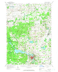
The Kalamazoo River winds through the heart of this landscape, its waters impounded behind a power plant to form the expansive Lake Allegan. To the west, the Allegan State Forest covers a significant portion of the terrain, illustrating the region's commitment to timber and conservation during the late 1950s. The city of Allegan serves as the primary hub, surrounded by a dense network of rural schoolhouses and small settlements such as Burnips and Dunningville.
Find a feature on this map
100 named features on this map. Tap any name to fly to it.
Don’t see what you’re looking for? This feature index may not catch every label — zoom into the map to look around manually.
Map Details
Editions of this 1958 Allegan Map
2 editions found
Other maps of this area

1914 · Grand Rapids
USGS Topo · 1:62,500

1916 · Kalamazoo
USGS Topo · 1:62,500

1918 · Kalamazoo
USGS Topo · 1:62,500

1927 · Bangor
USGS Topo · 1:62,500

1928 · Fennville
USGS Topo · 1:62,500

1929 · Holland
USGS Topo · 1:62,500

1931 · Fennville
USGS Topo · 1:62,500

1931 · Bangor
USGS Topo · 1:62,500

1932 · Holland
USGS Topo · 1:62,500

1943 · Kalamazoo
USGS Topo · 1:62,500