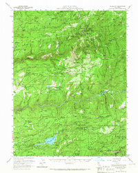
1950 Map of Alleghany
USGS Topo · Published 1966About this map
The gold-mining legacy of the Northern Sierra is etched into the landscape around Alleghany and the South Yuba River. This mid-century survey documents the transition from active industrial extraction to a landscape of historical remnants, featuring the massive hydraulic scars of the Malakoff Diggings and Alpha Diggings. The map preserves the locations of numerous family-named operations and sites like the Miller Ranch (Site) and Fivemile House, alongside active water management infrastructure like the Scotts Flat Reservoir.
Find a feature on this map
122 named features on this map. Tap any name to fly to it.
Don’t see what you’re looking for? This feature index may not catch every label — zoom into the map to look around manually.
Map Details
Editions of this 1950 Alleghany Map
4 editions found
Other maps of this area

1888 · Smartsville
USGS Topo · 1:125,000

1888 · Bidwell Bar
USGS Topo · 1:125,000

1891 · Bidwell Bar
USGS Topo · 1:125,000

1891 · Downieville
USGS Topo · 1:125,000

1891 · Colfax
USGS Topo · 1:125,000

1891 · Smartsville
USGS Topo · 1:125,000

1892 · Smartsville
USGS Topo · 1:125,000

1892 · Colfax
USGS Topo · 1:125,000

1893 · Bidwell Bar
USGS Topo · 1:125,000

1893 · Downieville
USGS Topo · 1:125,000