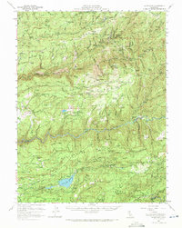
1950 Map of Alleghany
USGS Topo · Published 1972About this map
Alleghany and the surrounding Sierra Nevada foothills are captured here at mid-century, revealing a landscape deeply defined by its hydraulic mining heritage. This 1950s-era record details the extensive networks of Placer Diggings, Alpha Diggings, and Omega Diggings that carved the terrain near the South Yuba River. The settlement pattern reflects the area's industrial evolution, featuring established mining towns like North Bloomfield and North Columbia alongside numerous active and former mine sites such as the Kate Hardy Mine and Brush Creek Mine.
Find a feature on this map
129 named features on this map. Tap any name to fly to it.
Don’t see what you’re looking for? This feature index may not catch every label — zoom into the map to look around manually.
Map Details
Editions of this 1950 Alleghany Map
4 editions found
Other maps of this area

1888 · Smartsville
USGS Topo · 1:125,000

1888 · Bidwell Bar
USGS Topo · 1:125,000

1891 · Bidwell Bar
USGS Topo · 1:125,000

1891 · Downieville
USGS Topo · 1:125,000

1891 · Colfax
USGS Topo · 1:125,000

1891 · Smartsville
USGS Topo · 1:125,000

1892 · Smartsville
USGS Topo · 1:125,000

1892 · Colfax
USGS Topo · 1:125,000

1893 · Bidwell Bar
USGS Topo · 1:125,000

1893 · Downieville
USGS Topo · 1:125,000