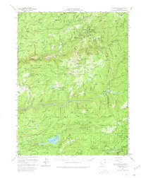
1950 Map of Alleghany
USGS Topo · Published 1980About this map
Sixteen to One Mine and the Plumbago Mine anchor this mid-century survey of the California gold country where Sierra and Nevada counties meet. The landscape is defined by the extensive hydraulic mining scars of the Malakoff Diggings, Alpha Diggings, and Omega Diggings, illustrating the scale of 19th-century industrial extraction along the Middle Fork Yuba River. Settlements like Alleghany, North Bloomfield, and Washington are shown alongside smaller family landmarks and rural infrastructure, including Clerkins Ranch, the Blue Tent School, and the White Cloud Guard Sta.
Find a feature on this map
161 named features on this map. Tap any name to fly to it.
Don’t see what you’re looking for? This feature index may not catch every label — zoom into the map to look around manually.
Map Details
Editions of this 1950 Alleghany Map
4 editions found
Other maps of this area

1888 · Smartsville
USGS Topo · 1:125,000

1888 · Bidwell Bar
USGS Topo · 1:125,000

1891 · Bidwell Bar
USGS Topo · 1:125,000

1891 · Downieville
USGS Topo · 1:125,000

1891 · Colfax
USGS Topo · 1:125,000

1891 · Smartsville
USGS Topo · 1:125,000

1892 · Smartsville
USGS Topo · 1:125,000

1892 · Colfax
USGS Topo · 1:125,000

1893 · Bidwell Bar
USGS Topo · 1:125,000

1893 · Downieville
USGS Topo · 1:125,000