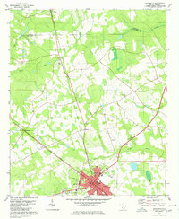
1979 Map of Allendale
USGS Topo · Published 1980About this map
Allendale serves as the focal point of this coastal plain survey, situated at the junction of the Seaboard Coast Line and Southern railroads. The town's educational and civic infrastructure is prominent, featuring the Univ of South Carolina Regional Campus, Allendale Academy, and several athletic fields. Beyond the town limits, the landscape is defined by the winding paths of Jackson Branch and Log Branch, interspersed with rural settlements like Appleton and Seigling. Small airports such as Sugar Hill Airport and Walker Airport indicate the importance of regional aviation during this period. The survey also captures numerous rural landmarks, including Mt Arnon Ch and New Zion Ch, which anchor the surrounding farmland near the Barnwell Co Allendale Co line.
Find a feature on this map
32 named features on this map. Tap any name to fly to it.
Don’t see what you’re looking for? This feature index may not catch every label — zoom into the map to look around manually.
Map Details
Editions of this 1979 Allendale Map
This is the sole edition of this map. No revisions or reprints were ever made.
Other maps of this area

1918 · Varnville
USGS Topo · 1:62,500

1919 · Olar
USGS Topo · 1:62,500

1919 · Allendale
USGS Topo · 1:62,500

1920 · Peeples
USGS Topo · 1:62,500

1943 · Olar
USGS Topo · 1:62,500

1943 · Allendale
USGS Topo · 1:62,500

1943 · Peeples
USGS Topo · 1:62,500

1944 · Varnville
USGS Topo · 1:62,500

1947 · Savannah
USGS Topo · 1:250,000

1948 · Savannah
USGS Topo · 1:250,000