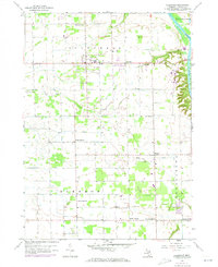
1958 Map of Allendale
USGS Topo · Published 1973About this map
Allendale and the surrounding townships of Blendon and Georgetown are captured here in a period of agricultural stability and early suburban transition. The landscape is defined by the winding course of the Grand River to the northeast and the drainage basins of Bass Creek and Little Bass Creek. Small rural hamlets like Pearline, North Blendon, and Bauer anchor the local road network, while several gravel pits and pits suggest the ongoing local extraction industry. Genealogists will find particular value in the distribution of community institutions across the countryside, including the Township Cem and Blendon Cem. The map preserves the locations of numerous district schools, such as White Sch No 2 and Corwin Sch No 3, many of which served as the social heart of their respective sections before the era of school consolidation.
Find a feature on this map
25 named features on this map. Tap any name to fly to it.
Don’t see what you’re looking for? This feature index may not catch every label — zoom into the map to look around manually.
Map Details
Editions of this 1958 Allendale Map
2 editions found
Other maps of this area

1929 · Holland
USGS Topo · 1:62,500

1930 · Muskegon
USGS Topo · 1:62,500

1932 · Holland
USGS Topo · 1:62,500

1936 · Muskegon
USGS Topo · 1:62,500

1945 · Ravenna
USGS Topo · 1:62,500

1954 · Milwaukee
USGS Topo · 1:250,000

1954 · Midland
USGS Topo · 1:250,000

1958 · Midland
USGS Topo · 1:250,000

1958 · Milwaukee
USGS Topo · 1:250,000

1958 · Allendale
USGS Topo · 1:24,000
Featured Places
- Hudsonville, MI
- Allendale Charter Township, MI
- Tallmadge Charter Township, MI
- Blendon Township, MI
- North Blendon, MI