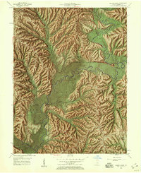
1957 Map of Allens Creek
USGS Topo · Published 1959About this map
Meandering through a landscape of deep hollows and timbered ridges, Salt Creek and its North Fork dominate this southern Monroe County terrain before the creation of Monroe Lake. This survey, revised in 1957, documents a rural network of family-named landmarks and upland communities like Fairfax and Handy. The map is particularly dense with community anchors for genealogists, including Mount Calvary Ch, Pine Grove Ch, and the Todd Cem.
Find a feature on this map
45 named features on this map. Tap any name to fly to it.
Don’t see what you’re looking for? This feature index may not catch every label — zoom into the map to look around manually.
Map Details
Editions of this 1957 Allens Creek Map
Other maps of this area

1908 · Bloomington
USGS Topo · 1:48,000

1910 · Bloomington
USGS Topo · 1:62,500

1934 · Bedford
USGS Topo · 1:48,000

1935 · Oolitic
USGS Topo · 1:48,000

1937 · Bedford
USGS Topo · 1:62,500

1942 · Franklin
USGS Topo · 1:125,000

1942 · Oolitic
USGS Topo · 1:62,500

1946 · Belmont
USGS Topo · 1:24,000

1947 · Allens Creek
USGS Topo · 1:24,000

1947 · Unionville
USGS Topo · 1:24,000