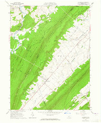
1963 Map of Allensville
USGS Topo · Published 1965About this map
Allensville sits at the heart of Big Valley, a landscape defined by the parallel ridges of Stone Mountain and Jacks Mountain. This 1963 field-checked survey reveals a rural society structured around the valley floor, where the Mennonite Cem and Presbyterian Cem signify the community's deep-rooted heritage. The map traces the transition from the forested heights of Rothrock State Forest to the productive agricultural lands drained by Big Valley Creek and Kishacoquillas Creek. A notable level of detail is given to the road network, including the Waynesburg Road and Front Road, which connect smaller nodes like Menno and Sharpsburg. The presence of Whitehall Sch and Waynesburg Sch illustrates the distribution of early 1960s educational infrastructure before major consolidation, while the Gravel Pit near the valley edge points to local geological extraction.
Find a feature on this map
52 named features on this map. Tap any name to fly to it.
Don’t see what you’re looking for? This feature index may not catch every label — zoom into the map to look around manually.
Map Details
Editions of this 1963 Allensville Map
Other maps of this area

1919 · Mattawana
USGS Topo · 1:62,500

1919 · Menno
USGS Topo · 1:62,500

1922 · Mt Union
USGS Topo · 1:48,000

1924 · Mt. Union
USGS Topo · 1:62,500

1924 · Lewistown
USGS Topo · 1:62,500

1927 · Lewisburg
USGS Topo · 1:62,500

1935 · Allensville
USGS Topo · 1:62,500

1936 · East Waterford
USGS Topo · 1:48,000

1938 · Allensville
USGS Topo · 1:62,500

1941 · East Waterford
USGS Topo · 1:62,500