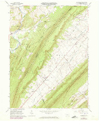
1963 Map of Allensville
USGS Topo · Published 1973About this map
Allensville sits at the heart of the Kishacoquillas Valley in this early 1960s survey, updated with purple-line revisions from 1972. The landscape is defined by the sharp, parallel ridges of the Ridge-and-Valley Appalachians, including Jacks Mountain and Stone Mountain. These ridges hem in agricultural valleys where small settlements like Menno, Rockville, and Sharpsburg are connected by local routes such as Waynesburg Road and Back Mountain Road.
Find a feature on this map
58 named features on this map. Tap any name to fly to it.
Don’t see what you’re looking for? This feature index may not catch every label — zoom into the map to look around manually.
Map Details
Editions of this 1963 Allensville Map
Other maps of this area

1919 · Mattawana
USGS Topo · 1:62,500

1919 · Menno
USGS Topo · 1:62,500

1922 · Mt Union
USGS Topo · 1:48,000

1924 · Mt. Union
USGS Topo · 1:62,500

1924 · Lewistown
USGS Topo · 1:62,500

1927 · Lewisburg
USGS Topo · 1:62,500

1935 · Allensville
USGS Topo · 1:62,500

1936 · East Waterford
USGS Topo · 1:48,000

1938 · Allensville
USGS Topo · 1:62,500

1941 · East Waterford
USGS Topo · 1:62,500