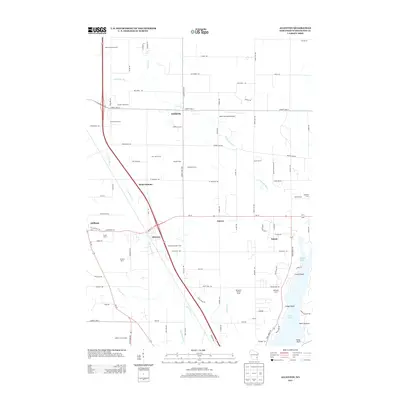
2013 Map of Allenton
USGS Topo · Published 2013About this map
The E Br Rock River winds southward through this portion of Washington County, anchoring a landscape defined by its agricultural heritage and small-town junctions. In Allenton, the intersection of the river and major thoroughfares marks a central hub of the township, while smaller communities like Kohlsville, Saint Anthony, and Nabob dot the surrounding countryside. This survey captures a modern view of the region's rural economy, where many properties are still identified by family and farm names such as Dominion Valley Farm, Goeller Family Farms, and Ihlenfeld Farms. To the east, the terrain transitions into lake country, featuring Gilbert Lake and the northern reaches of Cedar Lake, complete with distinct landmarks like Lone Island and Point Lookout. The presence of the Hahn Sky Ranch Airport north of Aurora highlights the continued integration of private aviation into this traditional dairy and farming belt.
Find a feature on this map
94 named features on this map. Tap any name to fly to it.
Don’t see what you’re looking for? This feature index may not catch every label — zoom into the map to look around manually.
Map Details
Editions of this 2013 Allenton Map
This is the sole edition of this map. No revisions or reprints were ever made.
Other maps of this area

1904 · West Bend
USGS Topo · 1:62,500

1904 · Hartford
USGS Topo · 1:62,500

1955 · Campbellsport
USGS Topo · 1:62,500

1955 · Kewaskum
USGS Topo · 1:62,500

1957 · Madison
USGS Topo · 1:250,000

1959 · West Bend
USGS Topo · 1:62,500

1959 · Hartford
USGS Topo · 1:62,500

1959 · Nenno
USGS Topo · 1:24,000

1959 · Allenton
USGS Topo · 1:24,000
1959 · Jackson
USGS Topo · 1:24,000