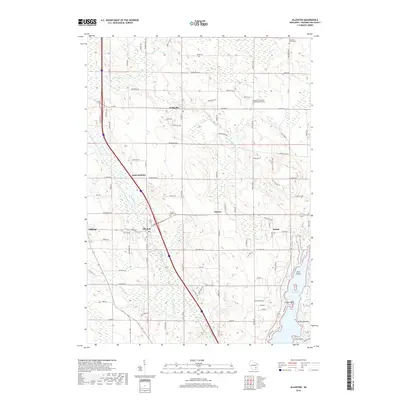
2018 Map of Allenton
USGS Topo · Published 2018About this map
Allenton serves as a primary hub in this Washington County landscape, where the E Br Rock River and Allenton Cr converge. The area is defined by a dense network of small unincorporated settlements including Kohlsville, Saint Anthony, Aurora, and Nabob, each connected by a grid of rural routes like Co Hwy D. The eastern edge of the survey is dominated by the deep waters of Cedar Lake, featuring distinct shore landmarks such as Linden Point and Point Lookout. Genealogists will find significant local history preserved at the Albright Evangelical United Brethren Cem and Sacred Heart Cem. From the northern reaches of the Wayne Marsh to the southern drainage of Limestone Cr, the map illustrates a well-established agricultural and residential community maintaining its traditional settlement patterns.
Find a feature on this map
57 named features on this map. Tap any name to fly to it.
Don’t see what you’re looking for? This feature index may not catch every label — zoom into the map to look around manually.
Map Details
Editions of this 2018 Allenton Map
This is the sole edition of this map. No revisions or reprints were ever made.
Other maps of this area

1904 · West Bend
USGS Topo · 1:62,500

1904 · Hartford
USGS Topo · 1:62,500

1955 · Campbellsport
USGS Topo · 1:62,500

1955 · Kewaskum
USGS Topo · 1:62,500

1957 · Madison
USGS Topo · 1:250,000

1959 · West Bend
USGS Topo · 1:62,500

1959 · Hartford
USGS Topo · 1:62,500

1959 · Nenno
USGS Topo · 1:24,000

1959 · Allenton
USGS Topo · 1:24,000
1959 · Jackson
USGS Topo · 1:24,000