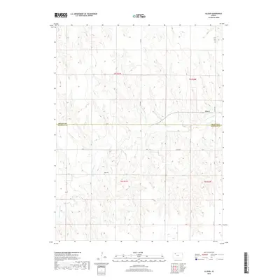
2018 Map of Allison
USGS Topo · Published 2018About this map
The N Fork Solomon River meanders across the High Plains of western Kansas, carving a distinct valley through the agricultural landscape of Decatur County. This 2018 survey documents a region defined by its wide, open sections and the vital watercourse that dictates the local geography. The small settlement of Allison sits near the river's edge, serving as a quiet focal point in a territory largely organized by the Public Land Survey System. Genealogical interest centers on the Adell Cem, located south of the river, which remains a permanent marker of the area's early residents and rural history. A network of county roads, including Co Rd 503 and Co Rd 509, provides the primary transit grid for the surrounding farms and ranches near the Decatur Co Sheridan Co boundary.
Find a feature on this map
12 named features on this map. Tap any name to fly to it.
Don’t see what you’re looking for? This feature index may not catch every label — zoom into the map to look around manually.
Map Details
Editions of this 2018 Allison Map
This is the sole edition of this map. No revisions or reprints were ever made.
Other maps of this area

1954 · Goodland
USGS Topo · 1:250,000

1956 · Goodland
USGS Topo · 1:250,000

1957 · Goodland
USGS Topo · 1:250,000

1978 · Clayton SW
USGS Topo · 1:24,000

1978 · Clayton
USGS Topo · 1:24,000
1978 · Dresden North
USGS Topo · 1:24,000
1978 · Jennings
USGS Topo · 1:24,000

1978 · Allison
USGS Topo · 1:24,000

1978 · Dresden South
USGS Topo · 1:24,000

1979 · Lucerne
USGS Topo · 1:24,000