
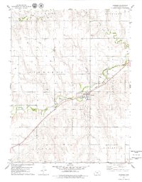
1978 Map of Clayton
USGS Topo · Published 1979About this map
Clayton serves as the primary hub of activity in this northwest Kansas landscape, situated where the Chicago Rock Island and Pacific railroad tracks parallel the winding course of Prairie Dog Creek. The local topography is defined by several drainage systems, including Plum Creek, Big Timber Cr, and Elk Creek, which cut through the high plains. Cultural landmarks such as the Gettis Cem and the settlement at Barnard provide specific points of interest for those tracing family history or early prairie development. The boundary between Decatur Co and Norton Co bisects the area, highlighting the town's position as a cross-county community. A network of light-duty and unimproved roads connects the various sections, including Pleasant Valley and Allison, while a prominent pipeline and infrastructure like the Radio Tower and Water Tank near Clayton reflect the modernizing utility of the late 1970s.
Find a feature on this map
18 named features on this map. Tap any name to fly to it.
Don’t see what you’re looking for? This feature index may not catch every label — zoom into the map to look around manually.
Map Details
Editions of this 1978 Clayton Map
This is the sole edition of this map. No revisions or reprints were ever made.
Other maps of this area

1951 · Norcatur
USGS Topo · 1:62,500

1951 · Kanona
USGS Topo · 1:62,500

1954 · Goodland
USGS Topo · 1:250,000

1956 · Goodland
USGS Topo · 1:250,000

1957 · Goodland
USGS Topo · 1:250,000

1965 · Kanona SE
USGS Topo · 1:24,000

1978 · Clayton SW
USGS Topo · 1:24,000
1978 · Jennings
USGS Topo · 1:24,000

1978 · Allison
USGS Topo · 1:24,000

1978 · Lenora West
USGS Topo · 1:24,000