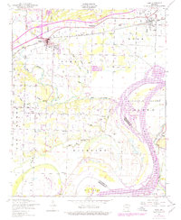
1948 Map of Alma
USGS Topo · Published 1978About this map
Alma and the surrounding Crawford County bottomlands are defined by the winding course of Frog Bayou as it approaches its confluence with the Arkansas River. This postwar landscape reflects a mix of traditional agriculture and emerging infrastructure, with the Missouri Pacific railroad corridor cutting through the northern settlements of Alma and Dyer. Local life in the mid-20th century is anchored by rural institutions like Pleasant Home Church and a series of family-named burial grounds, including Simmons Cemetery and Woods Cemetery. Southward toward the river, the terrain becomes more alluvial, dominated by the massive Arbuckle Island and the Courthouse Slough. An Abandoned mine near Mays Branch and the pumping station near Kibler indicate the local industrial footprint, while small communities such as New Town and Cross Lanes mark the transition from the rail-centered towns to the riverfront lowlands.
Find a feature on this map
38 named features on this map. Tap any name to fly to it.
Don’t see what you’re looking for? This feature index may not catch every label — zoom into the map to look around manually.
Map Details
Editions of this 1948 Alma Map
2 editions found
Other maps of this area

1879 · Fort Smith
USGS Topo · 1:62,500

1887 · Van Buren
USGS Topo · 1:62,500

1890 · Fort Smith
USGS Topo · 1:125,000

1898 · Winslow #4
USGS Topo · 1:62,500

1898 · Winslow #3
USGS Topo · 1:62,500

1898 · Winslow
USGS Topo · 1:125,000

1901 · Winslow
USGS Topo · 1:125,000

1906 · Lavaca
USGS Topo · 1:62,500

1943 · Fort Smith
USGS Topo · 1:125,000

1946 · Fort Smith
USGS Topo · 1:250,000