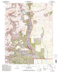
1994 Map of Alma
USGS Topo · Published 1998About this map
Mount Lincoln, Mount Cameron, and Mount Bross dominate the western horizon of this high-elevation study, where the legacy of hard-rock mining is etched into every canyon. The landscape is a dense network of extraction, centered around the Middle Fork South Platte River and its tributaries. Significant industrial footprints are visible at the Magnolia Mill and the Buckskin Joe Mine, illustrating the intense mineral pursuit that sustained local settlements. Historical sites such as Quartzville (Site) and Dudley (Site) represent the shifting fortunes of the region's mining camps. Further down the valley, Park City remains a focal point with its Park City Cem, providing a genealogical anchor for the district. The transition from industrial extraction to preservation is evident in the inclusion of the Bristlecone Pine Scenic Area and the Alma State Wildlife Area, marking a modern chapter for these peaks.
Find a feature on this map
54 named features on this map. Tap any name to fly to it.
Don’t see what you’re looking for? This feature index may not catch every label — zoom into the map to look around manually.
Map Details
Editions of this 1994 Alma Map
This is the sole edition of this map. No revisions or reprints were ever made.
Other maps of this area

1889 · Leadville
USGS Topo · 1:125,000

1891 · Leadville
USGS Topo · 1:125,000

1934 · Climax
USGS Topo · 1:48,000

1937 · Como
USGS Topo · 1:62,500

1938 · Mt. Lincoln
USGS Topo · 1:48,000

1942 · Leadville
USGS Topo · 1:125,000

1945 · Mount Lincoln
USGS Topo · 1:62,500

1953 · Denver
USGS Topo · 1:250,000

1956 · Fairplay East
USGS Topo · 1:24,000

1957 · Denver
USGS Topo · 1:250,000