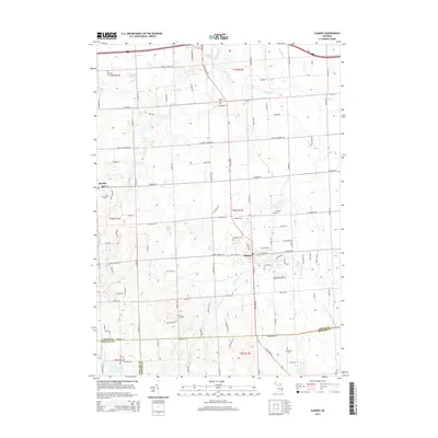
2014 Map of Almont
USGS Topo · Published 2014About this map
Almont and Dryden serve as the primary hubs of this agricultural landscape in the 2010s, situated where Lapeer, Macomb, and Oakland Counties meet. The terrain is defined by a complex drainage system, including the Belle River and the N Br Clinton River, alongside smaller bodies like McNally Lake and West Lake. For genealogists, the map is particularly valuable for its density of burial grounds, marking the history of local congregations and family plots through Bethany Mennonite Cem, Ferguson Cem, and Sand Hill Cem. The rectilinear road network, including the prominent Van Dyke Rd, illustrates the long-standing township-and-range land divisions that have organized this part of Michigan since early settlement. Small pockets of water like Pickeral Pond and Mud Lake provide insight into the local topography, contrasting with the structured grid of rural avenues and lanes.
Find a feature on this map
109 named features on this map. Tap any name to fly to it.
Don’t see what you’re looking for? This feature index may not catch every label — zoom into the map to look around manually.
Map Details
Editions of this 2014 Almont Map
This is the sole edition of this map. No revisions or reprints were ever made.
Other maps of this area

1914 · Armada
USGS Topo · 1:62,500

1928 · Armada
USGS Topo · 1:62,500

1943 · Lake Orion
USGS Topo · 1:24,000

1943 · Romeo
USGS Topo · 1:24,000

1945 · Armada
USGS Topo · 1:24,000

1945 · Almont
USGS Topo · 1:24,000

1945 · Allenton
USGS Topo · 1:24,000

1945 · Thornville
USGS Topo · 1:24,000

1945 · Romeo
USGS Topo · 1:24,000
1945 · Lake Orion
USGS Topo · 1:24,000