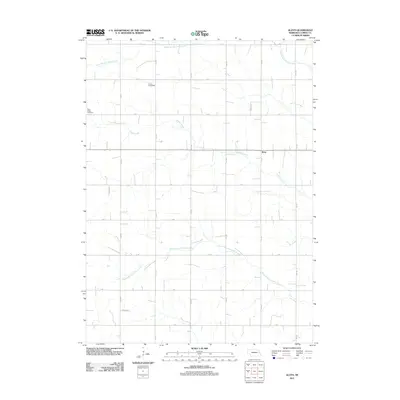
2011 Map of Aloys
USGS Topo · Published 2011About this map
Saint Peters Cemetery sits along the western edge of this agricultural landscape in Cuming County, where the topography is defined by the branching tributaries of the Pebble Creek system. The tiny settlement of Aloys is situated near the center of the quadrangle, serving as a quiet focal point within a vast grid of section roads. This 2011 survey reveals a landscape almost entirely dedicated to livestock and crop production, evidenced by facilities like Coufal Feedyards near the North Branch Pebble Creek. The map provides a precise look at the rural infrastructure of the early 21st century, from the strictly aligned path of 7th Rd to the meandering courses of the South Branch Pebble Creek. It is a portrait of Nebraska prairie life where the names of local roads and family-associated landmarks reflect the enduring pattern of Midwestern farmsteads.
Find a feature on this map
22 named features on this map. Tap any name to fly to it.
Don’t see what you’re looking for? This feature index may not catch every label — zoom into the map to look around manually.
Map Details
Editions of this 2011 Aloys Map
This is the sole edition of this map. No revisions or reprints were ever made.
Other maps of this area

1955 · Fremont
USGS Topo · 1:250,000

1957 · Fremont
USGS Topo · 1:250,000

1958 · Fremont
USGS Topo · 1:250,000

1963 · Wisner
USGS Topo · 1:24,000
1963 · Stanton NE
USGS Topo · 1:24,000

1966 · Monterey
USGS Topo · 1:24,000
1966 · Beemer
USGS Topo · 1:24,000

1966 · Snyder
USGS Topo · 1:24,000

1966 · Aloys
USGS Topo · 1:24,000

1966 · Clarkson
USGS Topo · 1:24,000