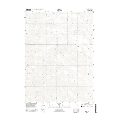
2014 Map of Aloys
USGS Topo · Published 2014About this map
Aloys is situated within a predominantly agricultural landscape of Cuming County, defined by a meticulously surveyed section-line road grid and the winding drainage of the Pebble Cr system. The topography is shaped by the N Br Pebble Cr and S Br Pebble Cr, which carve subtle valleys through the surrounding uplands. Local history is anchored by the Saint Peters Cem located in the western portion of the quadrangle, serving as a significant genealogical marker for the area's rural community. The map illustrates the transition between higher ground and the riparian corridors, while Ne-32 serves as the primary east-west corridor connecting these prairie settlements. This 2014 survey captures the enduring rural character of the region, where the intersection of water and transport has dictated the pattern of local homesteads and churchyards.
Find a feature on this map
14 named features on this map. Tap any name to fly to it.
Don’t see what you’re looking for? This feature index may not catch every label — zoom into the map to look around manually.
Map Details
Editions of this 2014 Aloys Map
This is the sole edition of this map. No revisions or reprints were ever made.
Other maps of this area

1955 · Fremont
USGS Topo · 1:250,000

1957 · Fremont
USGS Topo · 1:250,000

1958 · Fremont
USGS Topo · 1:250,000

1963 · Wisner
USGS Topo · 1:24,000
1963 · Stanton NE
USGS Topo · 1:24,000

1966 · Monterey
USGS Topo · 1:24,000
1966 · Beemer
USGS Topo · 1:24,000

1966 · Snyder
USGS Topo · 1:24,000

1966 · Aloys
USGS Topo · 1:24,000

1966 · Clarkson
USGS Topo · 1:24,000