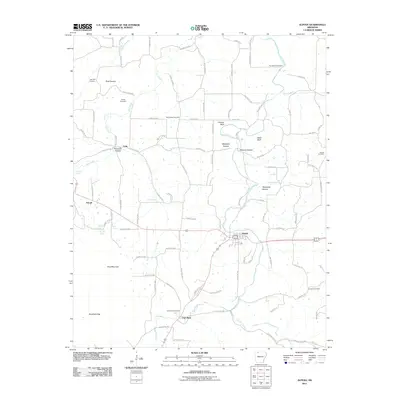
2011 Map of Alpena
USGS Topo · Published 2011About this map
Alpena and Carrollton anchor this topographic view of the Ozark landscape, illustrating the rural settlement patterns along the Long Creek corridor. The geography is defined by a series of named hollows and bluffs, such as Blackjack Hollow and Chaney Bluff, which dictate the winding paths of the county road network. The map provides significant genealogical value through its density of family and community burial grounds, including the Youngblood Cemetery near the northern boundary and the McCracken Cemetery centrally located among the farmsteads.
Find a feature on this map
103 named features on this map. Tap any name to fly to it.
Don’t see what you’re looking for? This feature index may not catch every label — zoom into the map to look around manually.
Map Details
Editions of this 2011 Alpena Map
This is the sole edition of this map. No revisions or reprints were ever made.
Other maps of this area

1904 · Harrison
USGS Topo · 1:125,000

1905 · Harrison
USGS Topo · 1:125,000

1945 · Harrison
USGS Topo · 1:250,000

1949 · Harrison
USGS Topo · 1:250,000

1954 · Harrison
USGS Topo · 1:250,000

1958 · Harrison
USGS Topo · 1:250,000

1964 · Harrison
USGS Topo · 1:250,000
1967 · Gaither
USGS Topo · 1:24,000
1967 · Omaha
USGS Topo · 1:24,000
1967 · Batavia
USGS Topo · 1:24,000