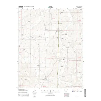
2014 Map of Alpena
USGS Topo · Published 2014About this map
Alpena and Carrollton anchor this survey of the northern Arkansas Ozarks at the boundary of Carroll Co and Boone Co. The landscape is defined by its water sources and deep topography, where settlements like Hough and Coin are surrounded by named hollows and bluffs. For family historians, the map is remarkably dense with burial sites, documenting Carrollton Cem, Dunkard Cem, Youngblood Cem, and several others across the rural townships. The drainage of Long Creek and Terrapin Cr dictates the path of the local road network, while the uplands feature landmarks such as Pine Mtn and Bradfield Gap. A Rock Quarry and the Deaf School Dr W provide evidence of local industry and infrastructure in this predominantly agricultural and residential region during the early twenty-first century.
Find a feature on this map
116 named features on this map. Tap any name to fly to it.
Don’t see what you’re looking for? This feature index may not catch every label — zoom into the map to look around manually.
Map Details
Editions of this 2014 Alpena Map
This is the sole edition of this map. No revisions or reprints were ever made.
Other maps of this area

1904 · Harrison
USGS Topo · 1:125,000

1905 · Harrison
USGS Topo · 1:125,000

1945 · Harrison
USGS Topo · 1:250,000

1949 · Harrison
USGS Topo · 1:250,000

1954 · Harrison
USGS Topo · 1:250,000

1958 · Harrison
USGS Topo · 1:250,000

1964 · Harrison
USGS Topo · 1:250,000
1967 · Gaither
USGS Topo · 1:24,000
1967 · Omaha
USGS Topo · 1:24,000
1967 · Batavia
USGS Topo · 1:24,000