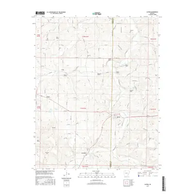
2017 Map of Alpena
USGS Topo · Published 2017About this map
Long Creek carves a deep valley through the Ozark plateau on the border of Carroll and Boone Counties, anchoring a rural landscape of scattered hamlets and family farmsteads. The crossroads of Alpena serves as a local hub, while the historically significant settlement of Carrollton sits further south along the creek, marked by the Carrollton Cem. The terrain is defined by its numerous springs and hollows, including Sycamore Spring, Bull Spring, and Blackjack Hollow. These water sources were vital for the early settlement of communities like Coin and Hough. High points such as Pine Mtn and bluffs like Chaney Bluff offer a glimpse into the topographical challenges faced by residents in the late twentieth century. Family history is etched into the landscape through numerous well-maintained burial grounds, from the Youngblood Cem in the north to the Duncard Cem on the eastern edge.
Find a feature on this map
104 named features on this map. Tap any name to fly to it.
Don’t see what you’re looking for? This feature index may not catch every label — zoom into the map to look around manually.
Map Details
Editions of this 2017 Alpena Map
This is the sole edition of this map. No revisions or reprints were ever made.
Other maps of this area

1904 · Harrison
USGS Topo · 1:125,000

1905 · Harrison
USGS Topo · 1:125,000

1945 · Harrison
USGS Topo · 1:250,000

1949 · Harrison
USGS Topo · 1:250,000

1954 · Harrison
USGS Topo · 1:250,000

1958 · Harrison
USGS Topo · 1:250,000

1964 · Harrison
USGS Topo · 1:250,000
1967 · Gaither
USGS Topo · 1:24,000
1967 · Omaha
USGS Topo · 1:24,000
1967 · Batavia
USGS Topo · 1:24,000