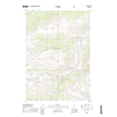
2020 Map of Alpine
USGS Topo · Published 2020About this map
Custer National Forest encompasses this high-elevation landscape, where the East Rosebud Creek Wild and Scenic River carves a path through the Beartooth Mountains. The small settlement of Alpine serves as a gateway to this drainage, situated near the shores of East Rosebud Lake at the end of E Rosebud Lake Rd. The map illustrates a high density of alpine water bodies, from West Rosebud Lake in the north to Rainbow Lake and Rimrock Lake in the south, linked by a network of drainages including Phantom Creek and Whirlpool Creek. Significant peaks like Saddleback Mtn and the uniquely named Mt Hole-in-the-Wall rise above Black Canyon. This survey captures the modern boundaries of the Stillwater and Carbon county line as it intersects these remote glaciated basins.
Find a feature on this map
47 named features on this map. Tap any name to fly to it.
Don’t see what you’re looking for? This feature index may not catch every label — zoom into the map to look around manually.
Map Details
Editions of this 2020 Alpine Map
This is the sole edition of this map. No revisions or reprints were ever made.
Other maps of this area

1898 · Granite Mountain District
USGS Topo · 1:125,000

1932 · Nye No 1
USGS Topo · 1:48,000

1932 · Nye No 2
USGS Topo · 1:48,000

1939 · Mt Wood
USGS Topo · 1:62,500

1941 · Mt. Wood
USGS Topo · 1:62,500

1954 · Billings
USGS Topo · 1:250,000
1956 · Emerald Lake
USGS Topo · 1:24,000

1956 · Alpine
USGS Topo · 1:62,500

1956 · Mackay Ranch
USGS Topo · 1:24,000

1956 · Cooke City
USGS Topo · 1:62,500