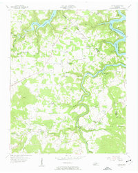
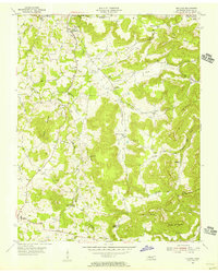
1956 Map of Alpine
USGS Topo · Published 1957About this map
The winding West Fork Obey River defines the rugged topography of this Overton County region, flowing northward into the recently created Dale Hollow Reservoir. Following a 1956 field check, the map records a landscape transitioning from traditional upland farming and timbering to a new era shaped by the reservoir's controlled inundation levels. Long-established communities such as Alpine, Monroe, and Wirmingham anchor the highland ridges, while smaller settlements like Nettlecarrier and Ivyton are situated along the lower creek valleys. The area is dense with family-named landmarks and cemeteries, including Green Hill Cem and Dugan Smith Cem, reflecting deep-rooted generational ties. Public life is centered around rural institutions such as Joppa Sch and McDonald Chapel, while the Pilot Lookout Tower stands as a sentinel over the southern heights of the quadrangle.
Find a feature on this map
60 named features on this map. Tap any name to fly to it.
Don’t see what you’re looking for? This feature index may not catch every label — zoom into the map to look around manually.
Map Details
Editions of this 1956 Alpine Map
3 editions found
Other maps of this area

1897 · Standingstone
USGS Topo · 1:125,000

1898 · Standingstone
USGS Topo · 1:125,000

1924 · Lillydale
USGS Topo · 1:62,500

1926 · Lillydale
USGS Topo · 1:62,500

1929 · Lillydale
USGS Topo · 1:62,500

1929 · Byrdstown
USGS Topo · 1:62,500

1944 · Livingston
USGS Topo · 1:24,000

1954 · Crawford
USGS Topo · 1:24,000
1955 · Livingston
USGS Topo · 1:24,000
1955 · Okalona
USGS Topo · 1:24,000