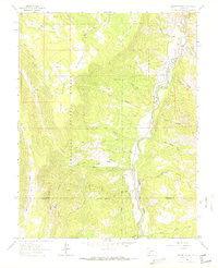
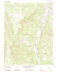
1963 Map of Alpine Plateau
USGS Topo · Published 1972About this map
The Lake Fork Gunnison River carves a deep valley through this high-altitude landscape on the boundary of Gunnison and Hinsdale counties. Established within the Uncompahgre National Forest, the terrain is defined by the broad Alpine Plateau and the meadows of Big Willow Park. Evidence of the region’s ranching and transit history is visible in the scattered homesteads such as Thomas Ranch, Thompson Ranch, and Ute Trail Ranch. Transportation in the early 1960s relied on the winding Alpine Road and specialized routes like the Stock Driveway, which provided movement for livestock through the mountain passes. Small settlements and markers like Youman and the community of Alpine anchor the local geography, while a lone Cem (cemetery) and the dramatic geologic formation known as The Gate provide specific points of interest for historical and genealogical research.
Find a feature on this map
36 named features on this map. Tap any name to fly to it.
Don’t see what you’re looking for? This feature index may not catch every label — zoom into the map to look around manually.
Map Details
Editions of this 1963 Alpine Plateau Map
5 editions found
Other maps of this area

1903 · Lake City
USGS Topo · 1:62,500

1905 · Lake City
USGS Topo · 1:62,500

1908 · Uncompahgre
USGS Topo · 1:125,000

1911 · Uncompahgre
USGS Topo · 1:125,000

1954 · Gateview
USGS Topo · 1:24,000

1956 · Montrose
USGS Topo · 1:250,000

1959 · Montrose
USGS Topo · 1:250,000

1960 · Montrose
USGS Topo · 1:250,000
1963 · Sheep Mountain
USGS Topo · 1:24,000
1963 · Lake City
USGS Topo · 1:24,000