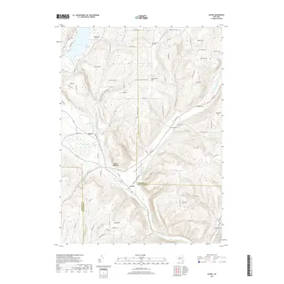
2019 Map of Alpine
USGS Topo · Published 2019About this map
Alpine and Alpine Junction sit within the high, undulating terrain where the borders of Tompkins, Schuyler, and Chemung counties converge. This landscape is defined by its deep glacial depressions and prominent heights, such as Connecticut Hill and Swan Hill, which overlook the northern reaches of Pony Hollow. The settlement at Cayuta serves as a central point along the southern drainage of Cayuta Creek, a waterway that originates at Cayuta Lake near the Lawrence Cem in the northwest. Local history is etched into the hillsides through family-named landmarks like VanLone Hill and Varney Hill, alongside scattered rural burials at the Connecticut Hill Cem and Estabrook Cem. The presence of the Kayutah Lake Airport and the winding course of the N Country National Scenic Trail illustrate a landscape used for both local transit and modern recreation amidst established dairy and timber country.
Find a feature on this map
83 named features on this map. Tap any name to fly to it.
Don’t see what you’re looking for? This feature index may not catch every label — zoom into the map to look around manually.
Map Details
Editions of this 2019 Alpine Map
This is the sole edition of this map. No revisions or reprints were ever made.
Other maps of this area

1893 · Ithaca
USGS Topo · 1:62,500

1895 · Ithaca
USGS Topo · 1:62,500

1895 · Elmira
USGS Topo · 1:62,500

1898 · Watkins Glen
USGS Topo · 1:62,500

1901 · Watkins
USGS Topo · 1:62,500

1902 · Waverly
USGS Topo · 1:62,500

1905 · Watkins Glen
USGS Topo · 1:125,000

1949 · Ithaca West
USGS Topo · 1:24,000

1950 · Elmira
USGS Topo · 1:250,000

1950 · Alpine
USGS Topo · 1:24,000